
Google/EDF
When discussing climate change, attention generally focuses on our soaring carbon dioxide emissions. But levels of methane have risen just as dramatically, and it’s a far more potent greenhouse gas. And, unlike carbon dioxide, it’s not the end result of a valuable process; methane largely ends up in the atmosphere as the result of waste, lost during extraction and distribution.
Getting these losses under control would be one of the easiest ways to slow down greenhouse warming. But tracking methane emissions often comes from lots of smaller, individual sources. To help get a handle on all the leaks, the Environmental Defense Fund has been working to put its own methane-monitoring satellite in orbit. On Wednesday, it announced that it was partnering with Google to take the data from the satellite, make it publicly available, and tie it to specific sources.
The case for MethaneSAT
Over the course of 20 years, methane is 84 times more potent than carbon dioxide when it comes to greenhouse warming. And most methane in the atmosphere ultimately reacts with oxygen, producing water vapor and carbon dioxide—both of which are also greenhouse gasses. Those numbers are offset by the fact that methane levels in the atmosphere are very low, currently just under two parts per million (versus over 400 ppm for CO2). Still, levels have gone up considerably since monitoring started.
The primary source of the excess methane is the extraction and distribution of natural gas. In the US, the EPA has developed rules meant to force companies with natural gas infrastructure to find and fix leaks. (Unsurprisingly, Texas plans to sue to block this rule.) But finding leaks has turned out to be a challenge. The US has been using industry-wide estimates that turned out to be much lower than numbers based on monitoring a subset of facilities.
Globally, that sort of detailed surveying simply isn’t possible, and we don’t have the type of satellite-based instruments we need to focus on methane emissions. A researcher behind one global survey said, “We were quite disappointed because we discovered that the sensitivity of our system was pretty low.” (The survey did identify sites that were “ultra emitters” despite the sensitivity issues.)
To help identify the major sources of methane release, the Environmental Defense Fund, a US-based NGO, has spun off a project called MethaneSAT that will monitor the emissions from space. The project is backed by large philanthropic donations and has partnered with the New Zealand Space Agency. The Rocket Lab launch company will build the satellite control center in New Zealand, while SpaceX will carry the 350 kg satellite to orbit in a shared launch, expected in early March.
Once in orbit, the hardware will use methane’s ability to absorb in the infrared—the same property that causes all the problems—to track emissions globally at a resolution down below a square kilometer.
Handling the data
That will generate large volumes of data that countries may struggle to interpret. That’s where the new Google partnership will come in. Google will use the same AI capability it has developed to map features such as roads and sidewalks on satellite images but repurpose it to identify oil and gas infrastructure. Both the MethaneSAT’s emissions data and infrastructure details will be combined and made available via the company’s Google Earth service.
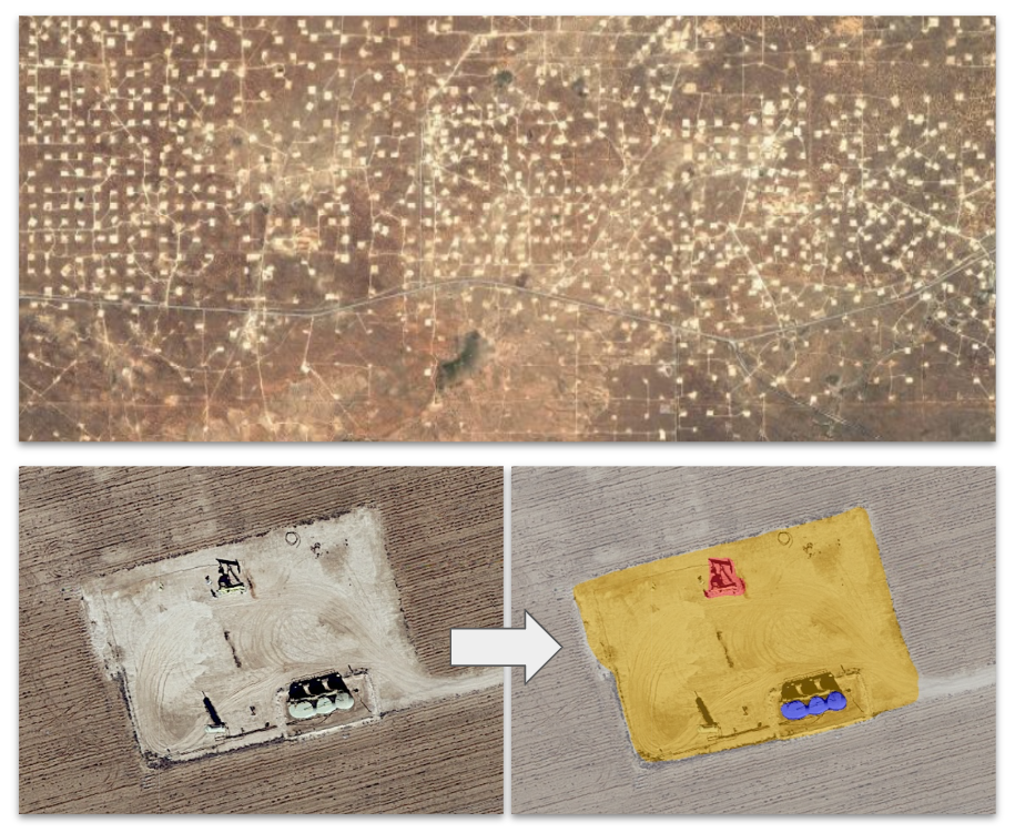
Top image: A view of an area undergoing oil/gas extraction. Left: a close-up of an individual drilling site. Right: Computer-generated color coding of the hardware present at the site.
Google / EDF
The project builds off work Google has done previously by placing methane monitoring hardware on Street View photography vehicles, also in collaboration with the Environmental Defense Fund.
In a press briefing, Google’s Yael Maguire said that the challenge is keeping things up to date, as infrastructure in the oil and gas industry can change fairly rapidly. While he didn’t use it as an example, one illustration of that challenge was the rapid development of liquified natural gas import infrastructure in Europe in the wake of Russia’s invasion of Ukraine.
The key question, however, is one of who’s going to use this information. Extraction companies could use it to identify the sites of leaks and fix them but are unlikely to do that in the absence of a regulatory requirement. Governments could rely on this information to take regulatory actions but will probably want some sort of independent vetting of the data before doing so. At the moment, all EDF is saying is that it’s engaging in discussions with several parties about potentially using the data.
One clear user will be the academic community, which is already using less-targeted satellite data to explore the issue of methane emissions.
Regardless, as everyone involved in the project emphasizes, getting methane under control is probably the easiest and quickest way to eliminate a bit of impending warming. And that could help countries meet emissions targets without immediately starting on some of the slower and more expensive options. So, even if no one has currently committed to using this data, they may ultimately come around—because using it to do something is better than doing nothing.
Source link